| General Discussion Undecided where to post - do it here. |
| Reply to Thread New Thread |
 01-22-2011, 05:42 AM
|
#1 |
|
|
I've been delaying working on the rest of my pictures because I've been back to work and life
has interrupted, and I knew that this next group had a lot of pictures I needed to merge together, and didn't think it would be easy. ... and, I was right! It's taken a fair amount of time and a few parts can't be shown. In any case, there are a lot of pictures so I'll post what I have in different groups. For our last major trip, we went to Silver City, which is home to lots of western legends... one of the places where a lot of 1800's bad guys used to hang out, and north of there over the mountains is the Gila National Wilderness Area. I thought the Adirondacks was a real wildnerness, which it is in it's own way, but this area can be very desolate, and very remote! To get to the Gila Cliff Dwellings, there is one road in and out. It's amazing that these people around 700 years ago were just wandering around this neck of the woods, and found the caves to put their adobe houses in. We had to cross the mountains north of Silver City, which meant a few hours of slow driving and lots of switchbacks, and rock formations up on the side hills that you could see briefly, but often no real place to stop; and if you happened to be driving and tried to look at something too long, you might miss a curve and drive down a very, long, steep drop! the first pictures are two merged areas in the mid-mountains starting to go down the other side towards the Gila park area; the first image is the view to the left or south, and the second merged grouping is a continuation just to the northwest (I couldn't get these two groups to play well and merge together). I had more views in the deep bottoms of the valley, but couldn't add them on properly 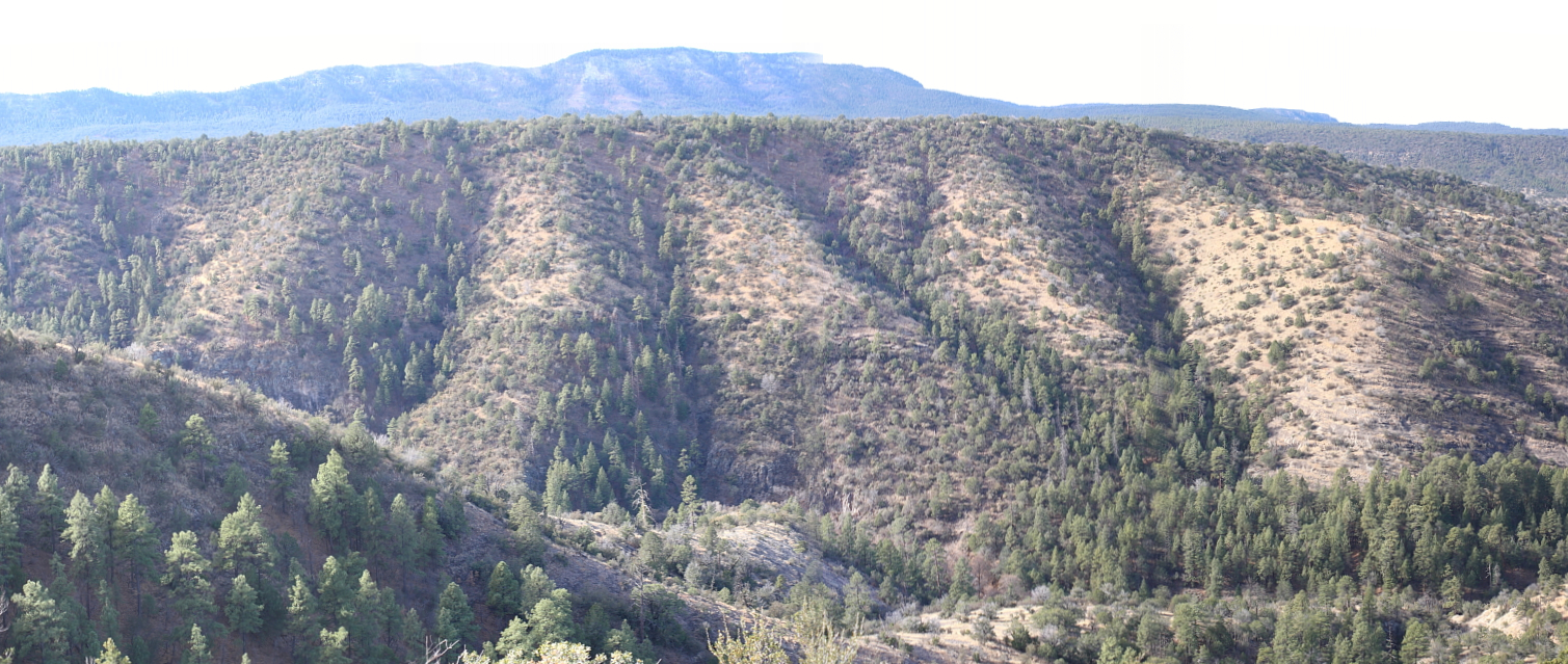 these pictures were taken right from the edge of the road. there were a number of parking spots where you could pull off literally within feet of an amazing drop down into the valley! my stepfather was joking that my mother probably wasn't too happy with his stopping there as she isn't crazy about heights, but I have to admit; though I don't usually have a problem with heights, when we would stop along the road and I would lean towards the side of the car with the drop, I would get the willies a little bit  that much open volume with such a steep drop is a bit intimidating! that much open volume with such a steep drop is a bit intimidating!  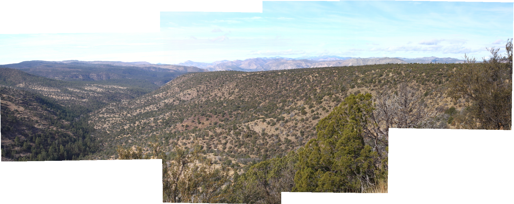 this really was an amazing area; there are lots of things I didn't take pictures of, and after a point it was difficult to decide what to try and take a picture of. the views were just endless and amazing, with mountains beyond mountains and more and more valleys. a person would want to take pictures endlessly to capture all the images, but there just was no way to do that. after a point, you just had to look and remember |

|


|
01-22-2011, 06:21 AM
|
#2 |
|
|
|
|
|
|
01-22-2011, 07:30 AM
|
#3 |
|
|
Great job on the panorama! What camera/program are you using?
|
|
|
|
01-22-2011, 08:22 PM
|
#4 |
|
|
here I was using my canon 30d; I first edit the pictures for size and try to match the brightness and detail on each, and then convert them to the same size and file type (using canon photo pro). then I use a program called photostitch to hook and merge them together. both programs came with the camera when I bought it. I think graphicconverter also has a merge thingy, but haven't tried it yet. if I take two consecutive pictures without enough overlap area, the program won't allow the two files to merge
 . technology is supposed to be helping us; I don't like it that it won't just glue the two together, if that's what you tell it to do (sigh). I guess I just want it to do magic! . technology is supposed to be helping us; I don't like it that it won't just glue the two together, if that's what you tell it to do (sigh). I guess I just want it to do magic!  more pictures soon |
|
|
|
01-22-2011, 10:20 PM
|
#5 |
|
|
|
|
|
|
01-22-2011, 10:58 PM
|
#6 |
|
|
more pics
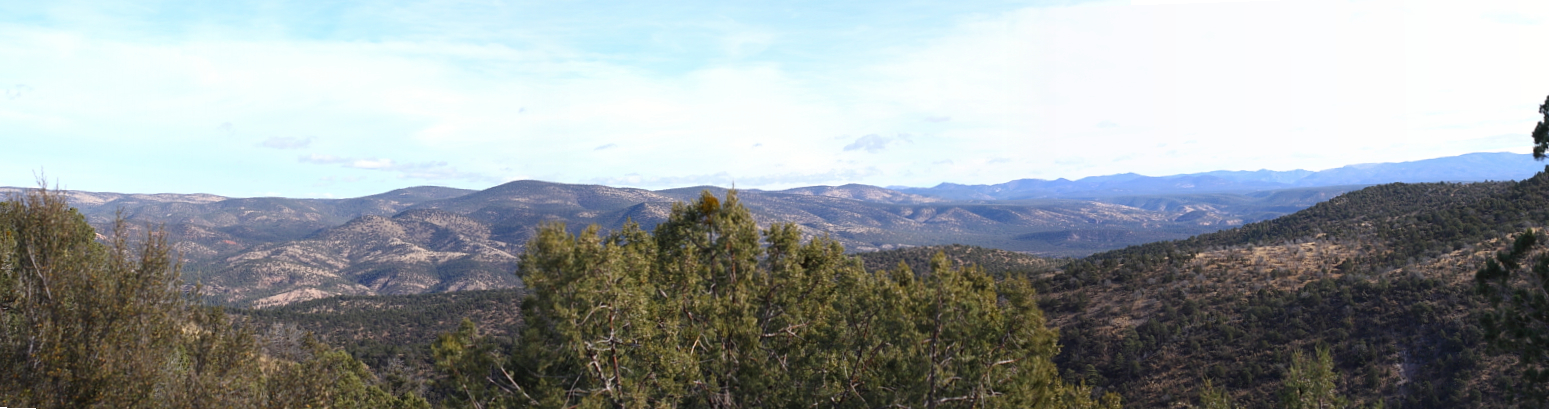 the two previous merged pics were on the 'left' side of the road; this merge is from the 'right' side. there was more, but couldn't make it look right the next pics are from the gila cave dwellings park I was surprised about the history of this cliff dwelling. I was also surprised that they were so small (in comparison to other dwellings further north) and that they were occupied for such a short period of time! our guide told us that this spot was only occupied by the people that built the adobe buildings for around 30 years. during this time period there were droughts in this part of the world and they had to find this spot because it offered water and protection, and a spot where they could grow food. scientists determined that they were only present here for around 30 years based upon remains of wood that they used, where the tree rings only spanned a 30-year time period. there also could have been other different indian tribes that had moved south into this general area and forced them to seek shelter in these caves. they subsisted mainly on pinion nuts from local pine trees, used yuccas for many things including clothing aids, tools and food, grew corn, beans and squash on the hill across the stream. the stream had water all year long since it was fed by a spring and they would haul water up to the other side to water their crops. one or two people would guard their crops from animals or human predators. it isn't known why this spot wasn't settled any longer than 30 years, or why another group didn't show up and use it later. some damage was done to the site from vandals of various sorts, and the original roofs were burned when looters entered the buildings in search of pottery to sell. this tribe of indians were likely from the 'pueblo' indian group, which was different than the ones which included apache, navajo and other related tribes. the corn they used had very small cobs and may have been more bush-like; as corn was traded further north and east, propagators used seed from plants that ended up greatly increasing the size of the corn cob. it originally was traded up from central mexico to this area, and i'm not sure if it had moved north to that area before that. one interesting thing is that botanists have searched for the original plant in central and south america which was so important for the survival of so many american indian tribes both in south, central and north america, but failed to find it. in this area, many would have starved during the drought periods because corn would be the only thing that would keep being stored into february. after this, rains would bring other plants into growth and there could be other things to eat. the guide did tell us that other migratory peoples used these caves for tanning hides and general shelter, but don't appear to have ever built structures inside the caves (a few thousand years ago). in comparison to european and other 'native american' people, these pueblo peoples were quite short. the openings into their structures were 'T' shaped, so that larger people trying to enter would have to lean forward, making it easier for someone defending the buildings inside (even a child) could easily whack them on the head to disable them 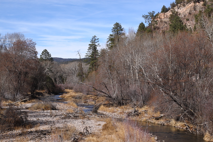 through the small valley here runs the gila river. i'm not sure if this is the gila river or a smaller stream which runs into it; this picture was taken from the bridge crossing the water from the visitor's center and the path which goes up to the cliff dwellings cave 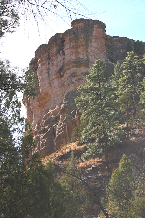 corner view of the formation that the caves are in; you can't quite see the curves where the caves open up around the left face of the cliff 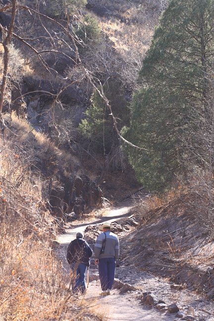 mother and stepfather walking up beginning of path along spring stream up by the caves. this area is so dry, when you walked up the path along the stream you could feel the moisture on your face. also, about where the people are in the photo, the above-ground water of the stream disappears into the gravel. during heavy rains there is considerable water that flows down this cut in the rocks 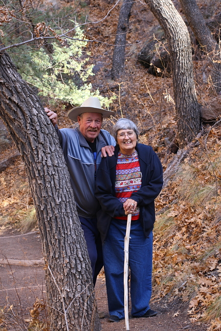 mother and stepfather 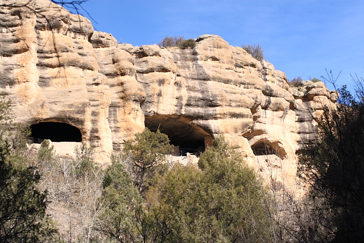 front of caves from vantage point part-way up the trail 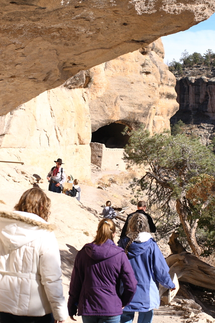 scheduled tour given by park ranger/tour guide. one of the young ladies in the tour answered many of the questions the guide asked, much to his surprise! taking the guided tour is longer than just walking around, but you get so much more out of the visit if you know and understand what you are looking at 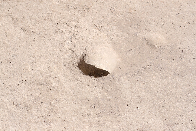 one of the holes in the rock floor where they would grind their grain  paintings on the ceiling of the storage or cooking areas. there are few actual petroglyphs here. most are of the snake or rattlesnake which is believed to indicate danger if you moved further into areas where the food was stored or the clan witch doctor's area was. people then believed that the symbols carried great power, and if they were to trespass into areas that had the protective or warning symbols in them, they would be harmed or worse (or punished if caught stealing or trespassing) more in another post |
|
|
|
01-23-2011, 06:09 AM
|
#7 |
|
|
|
|
|
|
01-27-2011, 11:30 PM
|
#8 |
|
|
|
|
|
 I need to go southwest!
| Reply to Thread New Thread |
«
Previous Thread
|
Next Thread
»
 Linear Mode

| Currently Active Users Viewing This Thread: 1 (0 members and 1 guests) | |
|
|

