| General Discussion Undecided where to post - do it here. |
| Reply to Thread New Thread |
 05-08-2012, 02:50 AM
|
#21 |
|
|
The answers you seek are in the book you never look at |

|


|
05-08-2012, 02:52 AM
|
#22 |
|
|
Supposedly these statues were created only 500 - 900 years ago.
|
|
|
|
05-08-2012, 03:15 AM
|
#23 |
|
|
Supposedly these statues were created only 500 - 900 years ago. |
|
|
|
05-08-2012, 03:25 AM
|
#24 |
|
|
Supposedly these statues were created only 500 - 900 years ago. Makes me think of The Revalations of the Pyramids video once again. I think they are much older that the official dates. |
|
|
|
05-08-2012, 04:36 AM
|
#25 |
|
|
I suppose the real question now is are they wearing shoes?
I think there's a Nike commercial already in the works. |
|
|
|
05-08-2012, 05:30 AM
|
#26 |
|
|
Yeah, and if those dates are correct, how did they get filled and from where? That's a lot of dirt in a relatively short amount of time and not much hill above them. Either that or they were pushed upright into the holes which were then backfilled. Each statue doesn't have it's own little mound, the whole area is elevated. I can't see people moving that much dirt. Regardless I would also think they are older. Seems like a lot of erosion for less then a thousand years. |
|
|
|
05-08-2012, 05:57 AM
|
#27 |
|
|
Regardless I would also think they are older. Seems like a lot of erosion for less then a thousand years. |
|
|
|
05-08-2012, 07:32 AM
|
#28 |
|
|
I think they all had eyes made of abalone shell which lights up in the sun light .
|
|
|
|
05-08-2012, 07:38 AM
|
#29 |
|
|
Easter Island is the world's most isolated inhabited island. It is also one of the most mysterious. Eastern Island is roughly midway between Chile and Tahiti. The triangular shaped island (Easter Island) is made mostly of volcanic rock. Small coral formations exist along the shoreline, but the lack of a coral reef has allowed the sea to cut cliffs around much of the island. The coastline has many lava tubes and volcanic caves. The only sandy beaches are on the northeast coast. Easter Island we think of of huge stone carved figures - Easter Island Stones (or Eastern Island Stones).
Ovahe Beach, North Shore The inhabitants of this charming and mysterious place called their land: Te Pito o TeHenua, 'the navel of the world.' It sits in the South Pacific Ocean 2,300 miles west of South America, 2,500 miles southeast of Tahiti, 4,300 miles south of Hawaii, 3,700 miles north of Antarctica. The closest other inhabited island is 1,260 miles away - tiny Pitcairn Island where the mutineers of the H.M.S. Bounty settled in 1790.  Archaeological evidence indicates discovery of the eastern island by Polynesians at about 400 AD. Archaeological evidence indicates discovery of the eastern island by Polynesians at about 400 AD. In 1722, a Dutch explorer, Jacob Roggeveen, sighted and visited the island. This happened to be on a Sunday, Easter Sunday to be precise, and the name stuck: Easter Island (Isla de Pascua in Spanish). What he discovered on Easter Island were three distinct groups of people, Dark skinned, Red skinned, and very Pale skinned People with red hair". The Polynesian name of the island is Rapanui, which is a name given by a Tahitian visitor in the 19th century who says that the island looked like the Tahitian island of 'Rapa,' but bigger, 'Nui.' Inhabitants are of Polynesian descent, but for decades anthropologists have argued the true origins of these people, some claiming that ancient South-American mariners settled the island first. What many early explorers who visited the easter island found, was a scattered population with almost no culture they could remember and without any links to the outside world. The Easter islanders were easy prey for 19th century slave traders which depreciated even more their precarious culture, knowledge of the past, and skills of the ancestors. 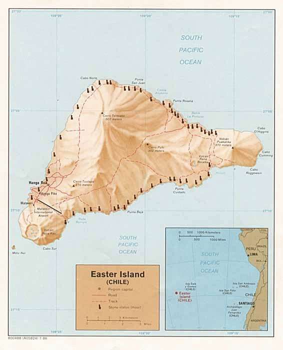 THE MOAI 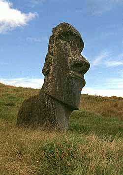 When we think of Eastern Island we think of of huge stone carved figures -monoliths- that dot the coastline. They are called Moai and are carved from island rock. The Moai are seen all over the island, and in different shapes, sizes, and stages of completion. Many Moaiare left unfinished at the quarry site. No one is sure yet as to what purposes did the Moai served, but outside scholarly research together with accumulated local knowledge, shows evidence that the Moai were carved by the ancestors of the present inhabitants. Ron Fisher in his work Easter Island Brooding Sentinels of Stone, mentions as one explanation for the statues that "two classes of people, the-so-called Long Ears and Short Ears, lived on the island. The Short Ears were enslaved by the Long Ears, who forced the Short Ears to carve the Moai. After many generations and during a rebellion, the Short Ears surprised the Long Ears killing them all, which explains the abrupt end of the statue-carving. 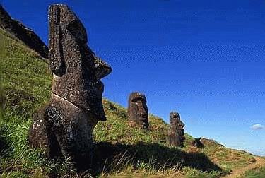 Long Ears Long EarsSome of the Moai face the sea - 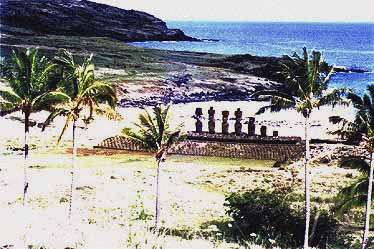 most face inland to watch over the villlages. Many of the were buried up to their shoulders and thereby appearing as disembodied heads. 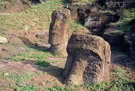 All of the Moai were toppled in tribal wars about 250 years ago. All of the Moai were toppled in tribal wars about 250 years ago. Many have recently been rebuilt - starting in the 1950's. They sit on rocky lava strewn about telling a story of fallen monuments of a long lost civilization who created them. The Moai were depictions of their ancestors. The Rapa Nui were ancestor worshipers and only had one diety - Make Make. The Moai were excavated for the first time by Thor Heyerdahl in the 1950's and were photographed at that time. AHU 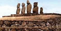 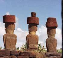 Moai sit on platforms - ceremonial shrines called Ahu. Ahu Akivi is an especially sacred place. Ahu Akivi is a sanctuary and celestial observatory built about 1500 AD which was the subject of the first serious restoration accomplished on Easter Island by archaeologists William Mulloy and Gonzalo Figueroa, with excellent results. As in the case of many religious structures on Easter Island, it has been situated with astronomical precision: it's seven statues look towards the point where the sun sets during the equinox.  It is also aligned to the moon. It is also aligned to the moon.Ahu Akivi is an unusual site in several respects. A low ahu supports 7 statues all very similar in height and style. The site is odd in that it is located far inland and the statues were erected to face the ocean. The only site where this was done. Like other Easter Island sites the statues were found knocked off the ahu, lying face down in the ground. In 1960, Archeologist William Mulloy's team spent several months raising the statues to their original positions. 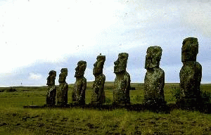 During the excavation and restoration of this site many cremation pits were uncovered behind the ahu. The pits contained fragments of bone, shells, fishing implements, and obsidian flakes. Whether sites like these were used regularly for cremations and or burials is not certain. At other sites skeletons have been found buried within the ahu structure, but these burials are believed to have occurred after the statues were toppled. During the excavation and restoration of this site many cremation pits were uncovered behind the ahu. The pits contained fragments of bone, shells, fishing implements, and obsidian flakes. Whether sites like these were used regularly for cremations and or burials is not certain. At other sites skeletons have been found buried within the ahu structure, but these burials are believed to have occurred after the statues were toppled. Folklore holds that its seven moai represent the seven young explorers that legend says the Polynesian King Hotu Matu'a dispatched from across the seas, probably from the Marquesas Islands, to find this new homeland for him and his people. They are among the few moai that face the sea. These seven stone giants may well symbolize those seven explorers, but no one knows for sure. Just as no one knows what any of the moai really represent or why only a few of them face the sea. http://www.lost-civilizations.net/ea...s-history.html |
|
|
|
05-08-2012, 12:23 PM
|
#30 |
|
|
So the question remains - are they buried intentionally or covered up over time? http://www.youtube.com/watch?v=pCvx5...eature=related |
|
|
|
05-13-2012, 05:19 AM
|
#31 |
|
|
|
|
|
|
05-13-2012, 02:18 PM
|
#32 |
|
|
cross posting from
Thread: Are the 2012 Olympics part of a plot to take over the world? (guardian.uk) from NASA's Project Blue Beam By Serge Monast (1994) Engineered Earthquakes & Hoaxed 'Discoveries' The first step in the NASA Blue Beam Project concerns the breakdown [re-evaluation] of all archaeological knowledge. It deals with the set-up, with artificially created earthquakes at certain precise locations on the planet, of supposedly new discoveries which will finally explain to all people the "error" of all fundamental religious doctrines. The falsification of this information will be used to make all nations believe that their religious doctrines have been misunderstood for centuries and misinterpreted. [...] Hoaxed "Discoveries' What is important to understand in the first step is that those earthquakes will hit at different parts of the world where scientific and archaeological teachings have indicated that arcane mysteries have been buried. By those types of earthquakes, it will be possible for scientists to rediscover those arcane mysteries which will be used to discredit all fundamental religious doctrines. This is the first preparation for the plan for humanity because what they want to do is destroy the beliefs of all Christians and Muslims on the planet. To do that, they need some false 'proof' from the far past that will prove to all nations that their religions have all been misinterpreted and misunderstood. Hang On All Is Being Revealed Saturday, May 5th, 2012. Filed under: Alternative Knowledge Amazing Universe Esoterica Inspiration media and politics Spirituality The Awakening  by Zen Gardner What a perfect analogy. The Truth is coming to light in so many areas right now and this excavation is so representative of this entire phenomenon. All along we thought these were just massive heads that were mysteriously placed here on Easter Island by a civilization gone by, for whatever esoteric purpose.  Only now just a few months ago we find out theyre whole enormous statueswhich makes it even more fantastic. Jokes on us!  Lets Get to the Bottom of This more: http://www.zengardner.com/hang-on-al...eing-revealed/ & Thread: The Easter Island Heads Have Full Bodies! **** I'm already fairly confident that earthquakes are being created artificially: Japan, Haiti, that recent one in Mexico which corresponded perfectly with an "earthquake drill" by the gummit... Mexican Earthquake Coincides With Drill Based Around Exact Same Scenario Bizarre Coincidence: Government-run simulation also had earthquake measuring 7.9 on Richter scale Paul Joseph Watson Infowars.com Wednesday, March 21, 2012 sott.net: Massive drill in Mexico coincides with real earthquake |
|
|
|
08-09-2012, 11:07 PM
|
#33 |
|
|
It's really not even that hard.
We moved a 10,000 lb (?) Italian spiral staircase across a field and up a hill on little dowel rods. The electricians were in awe that we never toppled it or scratched it one bit, they bet against us and bought the beer for that day. It was said that the staircase was worth 75K. |
|
|
|
08-10-2012, 12:54 AM
|
#34 |
|
|
All of those explanation sound compelling but I have the the definitive one here
 http://www.lawofone.info/results.php?s=20&ss=1 20.30 Questioner: What technique did the Orion group use to give this information? Ra: I am Ra. The technique used was of two kinds: one, the thought transfer or what you may call “telepathy”; Two, the arrangement of certain stones in order to suggest strong influences of power, this being those of statues and of rock formations in your Pacific areas, as you now call them, and to an extent in your Central American regions, as you now understand them. 20.31 Questioner: Were you speaking in part of the stone heads of Easter Island? Ra: I am Ra. This is correct. |
|
|
|
08-10-2012, 01:08 AM
|
#35 |
|
|
I have visited Easter Island a number of times, and also Pitcairn. They are both interesting and pleasant places. Notably is the scarcity of bird life, as eggs are collected and eaten whenever possible.
Easter Island is the world's most isolated inhabited island. It is also one of the most mysterious. Eastern Island is roughly midway between Chile and Tahiti. The triangular shaped island (Easter Island) is made mostly of volcanic rock. Small coral formations exist along the shoreline, but the lack of a coral reef has allowed the sea to cut cliffs around much of the island. The coastline has many lava tubes and volcanic caves. The only sandy beaches are on the Northeast coast. |
|
|
|
08-10-2012, 03:06 AM
|
#36 |
|
|
Makes me wonder if perhaps a large flood covered them up to the necks in sediment.... |
|
|
| Reply to Thread New Thread |
«
Previous Thread
|
Next Thread
»
 Linear Mode

| Currently Active Users Viewing This Thread: 1 (0 members and 1 guests) | |
|
|

