| Reply to Thread New Thread |
|
|
#1 |
|
|
This Is the Apocalyptic Storm Hitting the US Right Now
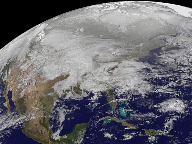
Get ready, because the snowpocalypse is back. This snow storm system is huge. NASA Goddard has released this amazing image, showing how it looks from space—bloody scary, that's how.   This Is the Apocalyptic Storm Hitting the US Right NowThe image was captured by the GOES-13 satellite, operated by NOAA. In this graphic, the red and pink areas is where the most intense action is. They say that this "massive winter storm affecting a large portion of great plains and midwest" is just getting worse: A large swath of blizzard warnings, winter storm warnings, freezing rain advisories, winter weather advisories and winter storm watches are in effect, stretching from New Mexico and the Southern Plains northeastward through the Midwest and into the upper Mid-Atlantic and New England.  This Is the Apocalyptic Storm Hitting the US Right NowAccording to NOAA, the storm will hit really hard over Texas tonight, "and intensify rapidly as it moves northeast into the Ohio Valley Tuesday night and Wednesday, then eventually re-form off the mid-Atlantic or New England coast late Wednesday." In other words: Expect extreme travel disruption and lots of snow zombies over the next 48 hours. |
|
|
|
|
#2 |
|
|
Major Winter Storm Takes Aim at Central U.S.
NASA image release January 31, 2011 This visible image was captured by the GOES-13 satellite and shows the low pressure area bringing snowfall to the Midwest Jan. 31, 2011. Heavy snow is expected today in portions of northern Iowa, southern Minnesota and Wisconsin. Snowfall from the system extends from Michigan west to Montana, Idaho, Utah and Arizona. A mix of rain and snow also stretches into the Ohio and Tennessee valleys, and it is all moving east. This system appears to be as large as 1/3rd of the Continental U.S. The image was created on Jan. 31 at 12:45 p.m. EST (1745 UTC) by the NASA GOES Project, located at NASA's Goddard Space Flight Center in Greenbelt, Md. The GOES series of satellites are operated by NOAA. 
|
|
|
|
|
#3 |
|
|
|
|
|
|
|
#4 |
|
|
|
|
|
|
|
#5 |
|
|
|
|
|
|
|
#6 |
|
|
 This satellite image provided by NOAA and taken Tuesday Feb. 1, 2011 at 10:45 EST shows a huge swath of the United States affected by a winter storm that has already brought layers of dangerous ice and blowing snow, closing roads and airports from Texas to Rhode Island. The storm's more than 2,000-mile reach threatened to leave about a third of the nation covered in a hodge-podge of harsh weather. Ice fell first and was expected to be followed by up to two feet of snow in some places |
|
|
|
|
#7 |
|
|
|
|
|
|
|
#9 |
|
|
|
|
|
| Reply to Thread New Thread |
«
Previous Thread
|
Next Thread
»
| Currently Active Users Viewing This Thread: 1 (0 members and 1 guests) | |
|
|


 Linear Mode


